 |
||||||||||||||||||
|
||||||||||||||||||


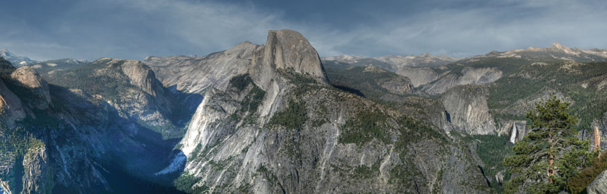
Yosemite Valley Panorama 2012
Location: Half Dome from Glacier Point. Yosemite National Park. Shot in June of 2012.
Find the location: Copy the coordinates below. Open Google Earth, paste the coordinates into "Fly To" and click on the magnifying glass.
37° 43’ 46.01” N
119° 34' 21.60” W
Equipment: Canon EOS 5D 28-105 lens (105 mm) at f 9.0 for 1/125 sec. ISO 50 with polarizing filter. Shot with Gigapan Epic Pro producing 21 images that were merged using the Gigapan software.
Digital imaging/manipulation: The 21 photos were combined to make a single image in the Gigapan software. That image was then tonemapped (as a single image) in Photomatrix 4.0 to adjust for the very dark Tenaya Canyon to the left of Half Dome. That left a cloudless sky. The sky was taken from a image shot in southern Utah in 2007 and inserted using Photoshop 5.0. Do you think I violated California law by importing a Utah sky without a license? At the very least, I probably owe somebody some taxes.
Notes: Great place for pictures of the valley. Sunset is the more colorful time of day but to get a panorama that is evenly exposed, you would need to shoot it during mid day. This was shot around 6:00 PM in June. Time of year also affects how directly the sun stikes the face of Half Dome. To get there, you leave Yosemite Valley and go south to Glacier Point Road. This is the way to Badger Pass Ski Area, Sentinal Dome, and eventually, Glacier Point. There is a large parking area at the end of the road.
If you experience any problems on this website, please contact the webmaster. Website designed by Dru Furbee.